
高德地圖之地理編碼
阿新 • • 發佈:2019-01-23
首先申明是地理編碼呢?地理編碼,又稱為地址匹配,是從已知的地址描述到對應的經緯度座標的轉換過程。該功能適用於根據使用者輸入的地址確認使用者具體位置的場景,常用於配送人員根據使用者輸入的具體地址找地點。既地理編碼(地址轉座標)。
下面一步步來看怎麼實現的:
1、繼承 OnGeocodeSearchListener 監聽。
2、構造 GeocodeSearch 物件,並設定監聽。
geocoderSearch = new GeocodeSearch(this);
geocoderSearch.setOnGeocodeSearchListener(this);
3、通過 GeocodeQuery(java.lang.String locationName, java.lang.String city) 設定查詢引數,呼叫 GeocodeSearch 的 getFromLocationNameAsyn(GeocodeQuery geocodeQuery) 方法發起請求。
// name表示地址,第二個引數表示查詢城市,中文或者中文全拼,citycode、adcode
GeocodeQuery query = new GeocodeQuery(name, "010");

geocoderSearch.getFromLocationNameAsyn(query);
4、通過回撥介面 onGeocodeSearched 解析返回的結果。
說明:
1)可以在回撥中解析result,獲取座標資訊。
2)返回結果成功或者失敗的響應碼。1000為成功
//地理編碼結果回撥
@Override
public void onGeocodeSearched(GeocodeResult result, int rCode) {
dismissDialog(); 貼個具體實現類
/**
* 地理編碼
* Created by dong.he on 2017-1-9
*/
public class GeocoderActivity extends Activity implements
OnGeocodeSearchListener, OnClickListener, LocationSource,
AMapLocationListener {
private ProgressDialog progDialog = null;
private GeocodeSearch geocoderSearch;
private String addressName;
private AMap aMap;
private MapView mapView;
private Marker geoMarker;
private EditText geoInput;
//定位
private LocationSource.OnLocationChangedListener mListener;
private AMapLocationClient mlocationClient;
private AMapLocationClientOption mLocationOption;
private Double myLat = 0.0, myLongt = 0.0;//我的當前位置的經緯度
private String cityCode = null;
private String currentCity = null;
@Override
protected void onCreate(Bundle savedInstanceState) {
super.onCreate(savedInstanceState);
setContentView(R.layout.geocoder_activity);
/*
* 設定離線地圖儲存目錄,在下載離線地圖或初始化地圖設定;
* 使用過程中可自行設定, 若自行設定了離線地圖儲存的路徑,
* 則需要在離線地圖下載和使用地圖頁面都進行路徑設定
* */
//Demo中為了其他介面可以使用下載的離線地圖,使用預設位置儲存,遮蔽了自定義設定
// MapsInitializer.sdcardDir =OffLineMapUtils.getSdCacheDir(this);
mapView = (MapView) findViewById(R.id.map);
mapView.onCreate(savedInstanceState);// 此方法必須重寫
init();
}
/**
* 初始化AMap物件
*/
private void init() {
if (aMap == null) {
aMap = mapView.getMap();
geoMarker = aMap.addMarker(new MarkerOptions().anchor(0.5f, 0.5f)
.icon(BitmapDescriptorFactory
.defaultMarker(BitmapDescriptorFactory.HUE_BLUE)));
setUpLocation();
}
geoInput = (EditText) findViewById(R.id.input_edittext);
findViewById(R.id.btn_search).setOnClickListener(this);
geocoderSearch = new GeocodeSearch(this);
geocoderSearch.setOnGeocodeSearchListener(this);
progDialog = new ProgressDialog(this);
}
/**
* 方法必須重寫
*/
@Override
protected void onResume() {
super.onResume();
mapView.onResume();
}
/**
* 方法必須重寫
*/
@Override
protected void onPause() {
super.onPause();
mapView.onPause();
}
/**
* 方法必須重寫
*/
@Override
protected void onSaveInstanceState(Bundle outState) {
super.onSaveInstanceState(outState);
mapView.onSaveInstanceState(outState);
}
/**
* 方法必須重寫
*/
@Override
protected void onDestroy() {
super.onDestroy();
mapView.onDestroy();
}
/**
* 顯示進度條對話方塊
*/
public void showDialog() {
progDialog.setProgressStyle(ProgressDialog.STYLE_SPINNER);
progDialog.setIndeterminate(false);
progDialog.setCancelable(true);
progDialog.setMessage("正在獲取地址");
progDialog.show();
}
/**
* 隱藏進度條對話方塊
*/
public void dismissDialog() {
if (progDialog != null) {
progDialog.dismiss();
}
}
/**
* 響應地理編碼
*/
public void getLatlon(final String name) {
showDialog();
GeocodeQuery query = new GeocodeQuery(name, cityCode);// 第一個引數表示地址,第二個引數表示查詢城市,中文或者中文全拼,citycode、adcode,
geocoderSearch.getFromLocationNameAsyn(query);// 設定同步地理編碼請求
}
/**
* 地理編碼查詢回撥
*/
@Override
public void onGeocodeSearched(GeocodeResult result, int rCode) {
dismissDialog();
if (rCode == AMapException.CODE_AMAP_SUCCESS) {
if (result != null && result.getGeocodeAddressList() != null
&& result.getGeocodeAddressList().size() > 0) {
GeocodeAddress address = result.getGeocodeAddressList().get(0);
aMap.animateCamera(CameraUpdateFactory.newLatLngZoom(
AMapUtil.convertToLatLng(address.getLatLonPoint()), 15));
geoMarker.setPosition(AMapUtil.convertToLatLng(address
.getLatLonPoint()));
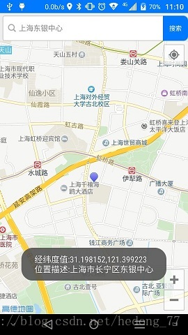
addressName = "經緯度值:" + address.getLatLonPoint() + "\n位置描述:"
+ address.getFormatAddress();
ToastUtil.show(GeocoderActivity.this, addressName);
} else {
ToastUtil.show(GeocoderActivity.this, R.string.no_result);
}
} else {
ToastUtil.showerror(this, rCode);
}
}
/**
* 逆地理編碼回撥
*/
@Override
public void onRegeocodeSearched(RegeocodeResult result, int rCode) {
}
@Override
public void onClick(View v) {
switch (v.getId()) {
/**
* 響應地理編碼按鈕
*/
case R.id.btn_search:
getLatlon(geoInput.getText().toString());
break;
default:
break;
}
}
/**
* 設定一些amap的屬性
*/
private void setUpLocation() {
aMap.setLocationSource(this);// 設定定位監聽
aMap.getUiSettings().setMyLocationButtonEnabled(true);// 設定預設定位按鈕是否顯示
aMap.setMyLocationEnabled(true);// 設定為true表示顯示定位層並可觸發定位,false表示隱藏定位層並不可觸發定位,預設是false
// 設定定位的型別為定位模式 ,可以由定位、跟隨或地圖根據面向方向旋轉幾種
aMap.setMyLocationType(AMap.LOCATION_TYPE_LOCATE);
}
/**
* 定位成功後回撥函式
*/
@Override
public void onLocationChanged(AMapLocation amapLocation) {
if (mListener != null && amapLocation != null) {
if (amapLocation != null
&& amapLocation.getErrorCode() == 0) {
//定位成功回撥資訊,設定相關訊息
amapLocation.getLocationType();//獲取當前定位結果來源,如網路定位結果,詳見定位型別表
myLat = amapLocation.getLatitude();//獲取緯度
myLongt = amapLocation.getLongitude();//獲取經度
amapLocation.getAccuracy();//獲取精度資訊
SimpleDateFormat df = new SimpleDateFormat("yyyy-MM-dd HH:mm:ss");
Date date = new Date(amapLocation.getTime());
df.format(date);//定位時間
amapLocation.getAddress();//地址,如果option中設定isNeedAddress為false,則沒有此結果,網路定位結果中會有地址資訊,GPS定位不返回地址資訊。
amapLocation.getCountry();//國家資訊
amapLocation.getProvince();//省資訊
currentCity = amapLocation.getCity();//城市資訊
amapLocation.getDistrict();//城區資訊
amapLocation.getStreet();//街道資訊
amapLocation.getStreetNum();//街道門牌號資訊
cityCode = amapLocation.getCityCode();//城市編碼
amapLocation.getAdCode();//地區編碼
TextView textView = (TextView) findViewById(R.id.city_detail);
textView.setText(amapLocation.getCity() + "=" + amapLocation.getDistrict() + "==" + amapLocation.getStreetNum());
mListener.onLocationChanged(amapLocation);// 顯示系統小藍點
} else {
String errText = "定位失敗," + amapLocation.getErrorCode() + ": " + amapLocation.getErrorInfo();
Log.e("AmapErr", errText);
}
}
}
/**
* 啟用定位
*/
@Override
public void activate(LocationSource.OnLocationChangedListener listener) {
mListener = listener;
if (mlocationClient == null) {
mlocationClient = new AMapLocationClient(this);
mLocationOption = new AMapLocationClientOption();
//設定定位監聽
mlocationClient.setLocationListener(this);
//設定為高精度定位模式
mLocationOption.setLocationMode(AMapLocationClientOption.AMapLocationMode.Hight_Accuracy);
//設定定位引數
mlocationClient.setLocationOption(mLocationOption);
// 此方法為每隔固定時間會發起一次定位請求,為了減少電量消耗或網路流量消耗,
// 注意設定合適的定位時間的間隔(最小間隔支援為2000ms),並且在合適時間呼叫stopLocation()方法來取消定位請求
// 在定位結束後,在合適的生命週期呼叫onDestroy()方法
// 在單次定位情況下,定位無論成功與否,都無需呼叫stopLocation()方法移除請求,定位sdk內部會移除
mlocationClient.startLocation();
}
}
/**
* 停止定位
*/
@Override
public void deactivate() {
mListener = null;
if (mlocationClient != null) {
mlocationClient.stopLocation();
mlocationClient.onDestroy();
}
mlocationClient = null;
}
}地理編碼其實就是這麼簡單。下一篇會繼續講逆地理編碼。