ArcGIS for Android 100.3.0(7):繪製圖層(GraphicsOverlay) ,符號和渲染器(Symbols and Renderers)
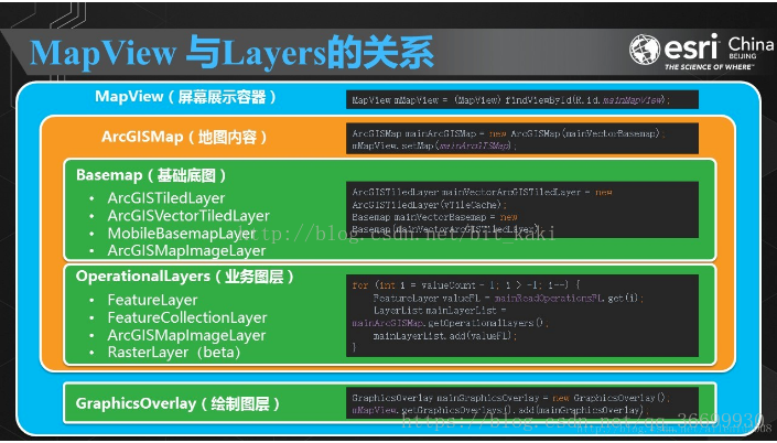
繪製圖層GraphicsOverlay
100版本單獨把繪製圖層拿出來的一個好處就是,它將永遠置於地圖內容之上。在以前我們如果要在MapView里加載一個新的圖層,必須先remove帶有圖形的FeatureLayer,載入這個圖層之後再載入一次帶有圖形的FeatureLayer,否則我們這個FeatureLayer將會被新載入的圖層所覆蓋。現在這個問題就不復存在了。
GraphicsOverlay graphicsOverlay1 = new GraphicsOverlay();
GraphicsOverlay graphicsOverlay2 = new GraphicsOverlay(GraphicsOverlay.RenderingMode GraphicsOverlay預設的構造模式一共有兩種:DYNAMIC和STATIC,預設的是動態渲染模式DYNAMIC。
當為DYNAMIC模式時候,每當圖形有變化時候GraphicsOverlay會立刻更新圖形;
而為STATIC模式時候,圖形變化了不會馬上更新,而是在進行地圖的縮放、旋轉和平移時候才更新圖層,適合於繪製圖層裡含有大量圖形時候使用,以防圖形更新太慢影響體驗。
舉個例子:繪製點
mMapView.setOnTouchListener(new DefaultMapViewOnTouchListener(this, mMapView) {
@Override
public boolean onSingleTapConfirmed(MotionEvent v) {
Point clickPoint = mMapView.screenToLocation 符號與渲染器(Symbols and Renderers),通過色彩值、大小、形狀、邊線、透明度來表達空間要素的具體含義。如果僅僅有位置,而沒有位置上的屬性資訊,位置也會失去意義,符號與渲染器是呈現位置上屬性資訊的最直接表達方式。對於Graphic(GraphicsOverlay),可以直接賦值符號或者設定渲染器,而對於Feature(FeatureLayer)只能通過渲染器進行設定。
符號Symbol使用
Symbol類是一個用來控制顯示圖形符號樣式的類。
1.點符號(MarkerSymbol)
點符號,顧名思義就是用來修飾Point的符號。包含三種類型,分別是
PictureMarkerSymbol(圖片點符號),
SimpleMarkerSymbol(簡單點符號),
TextSymbol(文字符號)。
2.線符號(LineSymbol)
線符號是用來修飾線PolyLine的符號。只有一種型別,SimpleLineSymbol(簡單線符號)。
3.面符號(FillSymbol)
面符號是用來修飾面Polygon的符號,一共有兩種PictureFillSymbol(圖片面符號), SimpleFillSymbol(簡單面符號)。
渲染Renderer使用
渲染也是設定圖形樣式,相比起符號來,渲染就相當於是批量的圖形樣式設定。但是當渲染和符號同時存在時候,會優先使用符號的樣式。
渲染一共包含了ClassBreaksRenderer, HeatmapRenderer, SimpleRenderer, UniqueValueRenderer, UnsupportedRenderer五大類,這裡簡要以SimpleRenderer介紹下吧。
單一符號渲染(SimpleRenderer)
官方案例:
public class AddGraphicsRendererActivity extends AppCompatActivity {

    private MapView mMapView;

    @Override
    protected void onCreate(Bundle savedInstanceState) {
        super.onCreate(savedInstanceState);
        setContentView(R.layout.activity_add_graphics_renderer);
        mMapView = (MapView) findViewById(R.id.mapView);
        ArcGISMap mMap = new ArcGISMap(Basemap.Type.TOPOGRAPHIC, 15.169193, 16.333479, 2);
        addGraphicsOverlay();
        mMapView.setMap(mMap);
    }

    private void addGraphicsOverlay() {
        // point graphic
        Point pointGeometry = new Point(40e5, 40e5, SpatialReferences.getWebMercator());
        // red diamond point symbol
        SimpleMarkerSymbol pointSymbol = new SimpleMarkerSymbol(SimpleMarkerSymbol.Style.DIAMOND, Color.RED, 10);
        // create graphic for point
        Graphic pointGraphic = new Graphic(pointGeometry);
        // create a graphic overlay for the point
        GraphicsOverlay pointGraphicOverlay = new GraphicsOverlay();
        // create simple renderer
        SimpleRenderer pointRenderer = new SimpleRenderer(pointSymbol);
        pointGraphicOverlay.setRenderer(pointRenderer);
        // add graphic to overlay
        pointGraphicOverlay.getGraphics().add(pointGraphic);
        // add graphics overlay to the MapView
        mMapView.getGraphicsOverlays().add(pointGraphicOverlay);

        // line graphic
        PolylineBuilder lineGeometry = new PolylineBuilder(SpatialReferences.getWebMercator());
        lineGeometry.addPoint(-10e5, 40e5);
        lineGeometry.addPoint(20e5, 50e5);
        // solid blue line symbol
        SimpleLineSymbol lineSymbol = new SimpleLineSymbol(SimpleLineSymbol.Style.SOLID, Color.BLUE, 5);
        // create graphic for polyline
        Graphic lineGraphic = new Graphic(lineGeometry.toGeometry());
        // create graphic overlay for polyline
        GraphicsOverlay lineGraphicOverlay = new GraphicsOverlay();
        // create simple renderer
        SimpleRenderer lineRenderer = new SimpleRenderer(lineSymbol);
        // add graphic to overlay
        lineGraphicOverlay.setRenderer(lineRenderer);
        // add graphic to overlay
        lineGraphicOverlay.getGraphics().add(lineGraphic);
        // add graphics overlay to the MapView
        mMapView.getGraphicsOverlays().add(lineGraphicOverlay);

        //polygon graphic
        PolygonBuilder polygonGeometry = new PolygonBuilder(SpatialReferences.getWebMercator());
        polygonGeometry.addPoint(-20e5, 20e5);
        polygonGeometry.addPoint(20e5, 20e5);
        polygonGeometry.addPoint(20e5, -20e5);
        polygonGeometry.addPoint(-20e5, -20e5);
        // solid yellow polygon symbol
        SimpleFillSymbol polygonSymbol = new SimpleFillSymbol(SimpleFillSymbol.Style.SOLID, Color.YELLOW, null);
        // create graphic for polygon
        Graphic polygonGraphic = new Graphic(polygonGeometry.toGeometry());
        // create graphic overlay for polygon
        GraphicsOverlay polygonGraphicOverlay = new GraphicsOverlay();
        // create simple renderer
        SimpleRenderer polygonRenderer = new SimpleRenderer(polygonSymbol);
        // add graphic to overlay
        polygonGraphicOverlay.setRenderer(polygonRenderer);
        // add graphic to overlay
        polygonGraphicOverlay.getGraphics().add(polygonGraphic);
        // add graphics overlay to MapView
        mMapView.getGraphicsOverlays().add(polygonGraphicOverlay);

    }

    @Override
    protected void onPause() {
        super.onPause();
        mMapView.pause();
    }

    @Override
    protected void onResume() {
        super.onResume();
        mMapView.resume();
    }

    @Override
    protected void onDestroy() {
        super.onDestroy();
        mMapView.dispose();
    }
}
效果圖:
唯一值渲染(UniqueValueRenderer)
UniqueValueRenderer表示具有匹配屬性的功能/圖形組。這在名義或字串資料中最常見。
UniqueValueRenderer用於繪製具有不同符號的多個要素/圖形,並將UniqueValueRenderer中的欄位名稱與UniqueValues中的值進行匹配。
示例:使用UniqueValueRenderer對分割槽指定進行符號化:黃色表示“住宅”,紫色表示“工業”,紅色表示“商業”,等等。
public class UniqueValueRendererActivity extends AppCompatActivity {

    private MapView mMapView;

    private String sample_service_url = "https://sampleserver6.arcgisonline.com/arcgis/rest/services/Census/MapServer/3";


    @Override
    protected void onCreate(Bundle savedInstanceState) {
        super.onCreate(savedInstanceState);
        setContentView(R.layout.activity_unique_value_renderer);

        mMapView = (MapView) findViewById(R.id.mapView);

        ArcGISMap map = new ArcGISMap(Basemap.createTopographic());

        //[DocRef: Name=Unique Value Renderer, Topic=Symbols and Renderers, Category=Fundamentals]
        // Create service feature table
        ServiceFeatureTable serviceFeatureTable = new ServiceFeatureTable(sample_service_url);

        // Create the feature layer using the service feature table
        FeatureLayer featureLayer = new FeatureLayer(serviceFeatureTable);

        // Override the renderer of the feature layer with a new unique value renderer
        UniqueValueRenderer uniqueValueRenderer = new UniqueValueRenderer();

        // Set the field to use for the unique values
        //You can add multiple fields to be used for the renderer in the form of a list, in this case
        uniqueValueRenderer.getFieldNames().add("STATE_ABBR");
        // we are only adding a single field

        // Create the symbols to be used in the renderer
        SimpleFillSymbol defaultFillSymbol = new SimpleFillSymbol(SimpleFillSymbol.Style.NULL, Color.BLACK,
                new SimpleLineSymbol(SimpleLineSymbol.Style.SOLID, Color.GRAY, 2));

        SimpleFillSymbol californiaFillSymbol = new SimpleFillSymbol(SimpleFillSymbol.Style.SOLID, Color.RED,
                new SimpleLineSymbol(SimpleLineSymbol.Style.SOLID, Color.RED, 2));

        SimpleFillSymbol arizonaFillSymbol = new SimpleFillSymbol(SimpleFillSymbol.Style.SOLID, Color.GREEN,
                new SimpleLineSymbol(SimpleLineSymbol.Style.SOLID, Color.GREEN, 2));

        SimpleFillSymbol nevadaFillSymbol = new SimpleFillSymbol(SimpleFillSymbol.Style.SOLID, Color.BLUE,
                new SimpleLineSymbol(SimpleLineSymbol.Style.SOLID, Color.BLUE, 2));

        // Set default symbol
        uniqueValueRenderer.setDefaultSymbol(defaultFillSymbol);
        uniqueValueRenderer.setDefaultLabel("Other");

        // Set value for california
        List<Object> californiaValue = new ArrayList<>();
        // You add values associated with fields set on the unique value renderer.
        // If there are multiple values, they should be set in the same order as the fields are set
        californiaValue.add("CA");
        uniqueValueRenderer.getUniqueValues().add(
                new UniqueValueRenderer.UniqueValue("California", "State of California", californiaFillSymbol,
                        californiaValue));

        // Set value for arizona
        List<Object> arizonaValue = new ArrayList<>();
        // You add values associated with fields set on the unique value renderer.
        // If there are multiple values, they should be set in the same order as the fields are set
        arizonaValue.add("AZ");
        uniqueValueRenderer.getUniqueValues()
                .add(new UniqueValueRenderer.UniqueValue("Arizona", "State of Arizona", arizonaFillSymbol, arizonaValue));

        // Set value for nevada
        List<Object> nevadaValue = new ArrayList<>();
        // You add values associated with fields set on the unique value renderer.
        // If there are multiple values, they should be set in the same order as the fields are set
        nevadaValue.add("NV");
        uniqueValueRenderer.getUniqueValues()
                .add(new UniqueValueRenderer.UniqueValue("Nevada", "State of Nevada", nevadaFillSymbol, nevadaValue));

        // Set the renderer on the feature layer
        featureLayer.setRenderer(uniqueValueRenderer);
        //[DocRef: END]

        // add the layer to the map
        map.getOperationalLayers().add(featureLayer);

        map.setInitialViewpoint(new Viewpoint(
                new Envelope(-13893029.0, 3573174.0, -12038972.0, 5309823.0, SpatialReferences.getWebMercator())));

        // set the map to be displayed in the mapview
        mMapView.setMap(map);

    }

    @Override
    protected void onPause() {
        super.onPause();
        // pause MapView
        mMapView.pause();
    }

    @Override
    protected void onResume() {
        super.onResume();
        // resume MapView
        mMapView.resume();
    }

    @Override
    protected void onDestroy() {
        super.onDestroy();
        // dispose MapView
        mMapView.dispose();
    }
}


