
mongodb 判斷座標是否在指定多邊形區域內的方法
阿新 • • 發佈:2019-01-30
MongoDB是一個基於分散式檔案儲存的資料庫,並提供建立基於地理空間的索引的能力,本文將使用MongoDB 基於地理空間索引進行座標所在區域的判斷及使用。
1.使用百度拾取座標工具,在地圖上定義多邊形的座標點,並把每個點的座標儲存。
多邊形的座標點如下:
113.314882,23.163055
113.355845,23.167042
113.370289,23.149564
113.356779,23.129758
113.338238,23.13913
113.330979,23.124706
113.313588,23.140858
113.323865,23.158204
113.314882,23.163055
注意首尾座標必須一樣,這樣才能使多邊形閉合。
2.使用百度地圖開放平臺地圖JS Demo,把多邊形座標輸入,看看多邊形是否合適。
把以下程式碼替換原始碼編輯器中的內容,然後點選執行
<!DOCTYPE html>
<html>
<head>
<meta http-equiv="Content-Type" content="text/html; charset=utf-8" />
<meta name="viewport" content="initial-scale=1.0, user-scalable=no" 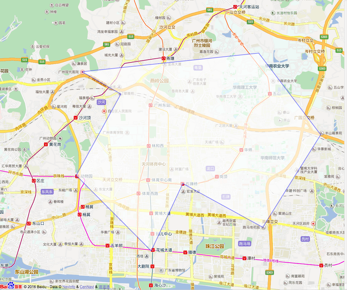
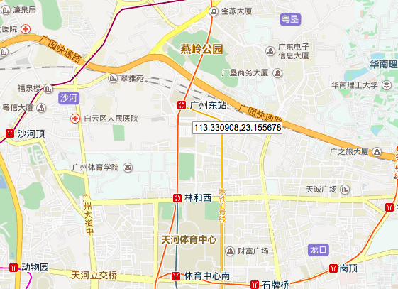
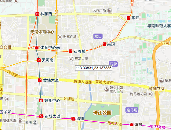
3.定義測試座標
廣州東站座標:113.330908,23.155678 (多邊形內)
巨集發大廈:113.33831,23.137335 (多邊形外)
4.在mongodb測試
1.建立資料庫
use testdb;

db.createUser(
    {
        "user":"root",
        "pwd":"123456",
        "roles":[{"role" : "readWrite", "db":"testdb"}]
    }
);

db.auth(
    {
        "user":"root",
        "pwd":"123456"
    }
);
2.插入多邊形範圍並新增索引
db.geo.ensureIndex(
    {
        polygons: "2dsphere"
    }
);

db.geo.insert(
    {
        polygons:
        {
            type:"Polygon",
            coordinates:[[
                [113.314882,23.163055],
                [113.355845,23.167042],
                [113.370289,23.149564],
                [113.356779,23.129758],
                [113.338238,23.13913],
                [113.330979,23.124706],
                [113.313588,23.140858],
                [113.323865,23.158204],
                [113.314882,23.163055],
            ]]
        }
    }
);
3.判斷座標是否在多邊形區域
廣州東站座標:113.330908,23.155678
db.geo.find(
    {
        polygons:
        {
            $geoIntersects:
            {
                $geometry:{
                    "type" : "Point",
                    "coordinates" : [113.330908,23.155678] }
                }
            }
        }
);
輸出:
{ "_id" : ObjectId("57c2b1895fb7fd4790f9f099"), "polygons" : { "type" : "Polygon", "coordinates" : [ [ [ 113.314882, 23.163055 ], [ 113.355845, 23.167042 ], [ 113.370289, 23.149564 ], [ 113.356779, 23.129758 ], [ 113.338238, 23.13913 ], [ 113.330979, 23.124706 ], [ 113.313588, 23.140858 ], [ 113.323865, 23.158204 ], [ 113.314882, 23.163055 ] ] ] } }表示座標 113.330908,23.155678 在多邊形區域內
巨集發大廈:113.33831,23.137335
db.geo.find(
    {
        polygons:
        {
            $geoIntersects:
            {
                $geometry:{
                    "type" : "Point",
                    "coordinates" : [113.33831,23.137335] }
                }
            }
        }
);輸出:空
表示座標 113.33831,23.137335 在多邊形區域外