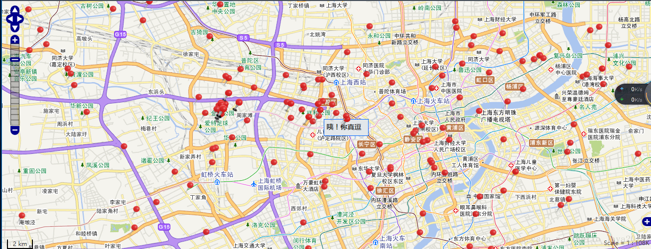
根據經緯度在地圖上新增標記,實現登陸使用者分佈地理位置,顯示使用者資訊
阿新 • • 發佈:2018-11-20
實現登陸使用者分佈地理位置標註,可以顯示使用者資訊
直接上乾貨(整個html網頁)
<!DOCTYPE html>
<html xmlns:th="http://www.thymeleaf.org">
<head>
<title>根據經緯度在地圖上新增標記</title>
<meta http-equiv="Content-Type" content="text/html; charset=utf-8">
<!-- 載入OpenLayers 類庫 -->
<script type="text/javascript" src="http://www.openlayers.cn/olapi/OpenLayers.js">
</script>
<!--jquery庫 -->
<script src="https://code.jquery.com/jquery-3.1.1.min.js"></script>
<style>
      body,html{
        width:99%;
        height: 100%;
        font-family: "arial, helvetica, sans-serif";
        font-size: x-large;
        font-kerning: inherit;
        font-stretch: expanded;
      }
      #map{
        height: 530px;
        font-size: 14px;
        font-family: "微軟雅黑";
        backface-visibility: visible;
        background-blend-mode: inherit;
        background-origin: border-box;
        background: content-box;
      }
    </style>
<script type="text/javascript">
$(document).ready(function() {
	init();
})
	function init() {
		var option = {
			controls : [ new OpenLayers.Control.Navigation(), //導航
			new OpenLayers.Control.PanZoomBar(), //放大縮小
			new OpenLayers.Control.Scale(), new OpenLayers.Control.ScaleLine(),
					new OpenLayers.Control.OverviewMap() ],
			numZoomLevels : 15
		//,//最大級別
		};
		map = new OpenLayers.Map('map', option);
		layer = new OpenLayers.Layer.WMTS({
			name : "中國底圖(向量)", //測試地址
			url : "http://t0.tianditu.com/vec_c/wmts", //中國底圖
			layer : "vec",
			style : "default",
			matrixSet : "c",
			format : "tiles",
			isBaseLayer : true
		});

		//測試使用,正式環境去掉
		var tdt2 = new OpenLayers.Layer.WMTS({
			name : "中國底圖註記",
			url : "http://t0.tianditu.com/cva_c/wmts", //中國底圖註記
			layer : "cva",
			style : "default",
			matrixSet : "c",
			format : "tiles",
			isBaseLayer : false
		});

		map.addLayers([ layer, tdt2 ]);
		//從伺服器獲取使用者資料進行繫結
		$.ajax({
			type : "POST",
			url : "請求介面",
			data : {
				"pageNumber" : "1" ,
				"pageSize" : "100"
			},
			dataType : "JSON",
			async : false,
			success : function(data) {
				$.each(data, function(i, item) {
					popupClass = OpenLayers.Popup.Anchored;
					addMarker(經度,緯度,popupClass, false,"<b>"+item.nickname(自己拼裝使用者資訊)+"</b>");//新增標記
				});
			},
			error : function() {
				alert("Error");
			}
		});
		map.setCenter(new OpenLayers.LonLat(116.5, 40).transform(
				new OpenLayers.Projection("EPSG:4326"), map
						.getProjectionObject()), 8);//預設放大級別7
		//map.zoomToMaxExtent();
		//顯示滑鼠位置座標
		map.addControl(new OpenLayers.Control.MousePosition({
			displayProjection : 'EPSG:4326'
		}));

	}

	//新增標記
	function addMarker(longitude,latitude,popupClass, closeBox,popupContentHTML,overflow) {
		var markers = new OpenLayers.Layer.Markers("分站");
		//設定顯示座標
		var x = 0, y = 0;
		//北京
		//圖片顯示
		var icon = new OpenLayers.Icon('顯示標註的小紅點的圖片路徑, {
			w : 21,
			h : 25
		}, {
			x : -10.5,
			y : -25
		});
		var feature = new OpenLayers.Feature(markers, new OpenLayers.LonLat(
			longitude, latitude).transform(
				new OpenLayers.Projection("EPSG:4326"), map
					.getProjectionObject()), {
				'icon' : icon
			});
		var marker = feature.createMarker();
		feature.closeBox = closeBox;
        feature.popupClass = popupClass;
        feature.data.popupContentHTML = popupContentHTML ;
        feature.data.overflow = (overflow) ? "auto" : "hidden";
        var markerClick = function (evt) {
            if (this.popup == null) {
			    this.createPopup(this.closeBox);
                this.popup.setBackgroundColor("#E2E7EB");
                this.popup.setBorder("1px #0066ff solid");
				this.popup.setSize(new OpenLayers.Size(80,24))
                map.addPopup(this.popup);
                this.popup.show();
            } else {
                this.popup.toggle();
            }
            currentPopup = this.popup;
            OpenLayers.Event.stop(evt);
        };
		var mousOut = function onPopupClose(evt) {
            map.removePopup(this.popup);
            this.popup.destroy();
            this.popup = null;
        }
        marker.events.register("mouseover", feature, markerClick);
		marker.events.register("mouseout", feature, mousOut);
        markers.addMarker(marker);
		map.addLayer(markers);
	}
</script>
</head>
<body class="page-container-bg-solid page-header-menu-fixed page-md">
<div th:replace="view/common/nav :: navbar" style="width:100%;hight:25%"></div>
<div id="map" style="width: 100%;"></div>
</body>

</html>


